1. Hahajima Kankokyoukai (Hahajima Tourism Association)
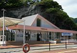
Located within the Oki Port Passenger Lounge. Gather tourism information about Hahajima here before heading out. Items such as original products are also being sold. There is a statue of a humpback whale on the grass next to the building. This is the starting point for the required times to destinations on this map.
2. Ross Museum
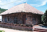
A local museum made from ross stone, which is found on Hahajima. It is resistant to heat and easy to mold. Daily tools, fishing tools, and devices for making sugar that were used before the war are on display. The ross stone was discovered by the German settler Rolfs, who settled on Hahajima and contributed to the cultivation of the island. It was used as a warehouse for sugar in the Taisho period.
2 minutes by car, 10 minutes on foot from the port [1]
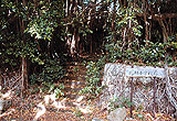
3. Grave of Mr. Rolfs and Mr. and Mrs. Moitley
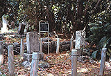
Located within the Okimura Bochi (Okimura Cemetery) above the municipal housings area, and is designated as a cultural asset of Tokyo. The Moitleys were British and are historically important people regarding the cultivation of Hahajima. Mr. Rolfs was German and became known for the discover of the ross stone. There is a place named after him on the island.
2 minutes on foot from [1]
4. Kiyomigaoka Shonyudo (Kiyomigaoka Limestone Cave)
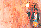
The area around Kiyomigaoka is a Karst region. The limestone cave can be entered from the door on the cliff behind the hexagonal hall. Along the side is a limestone wall called a Curtain. Although it is not very spacious, it is still possible to experience the feeling of exploring a cave with aerial roots of the Gajumaru (Ficus Microcarpa) hanging from above. People who wish to visit must sign up at the Hahajima Tourism Association.
5 minutes on foot from the port [1]
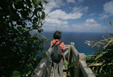
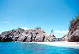
5. Samegasaki
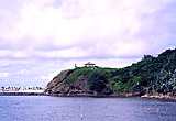
An observation deck at the entrance of the bay of Oki port. Okijima and Hirajima can be seen off shore. A good spot for whale watching from Januray to April, so binoculars are recommended during that season. The Hahajima Maru passes right in front.
10 minutes on foot from the port [1]
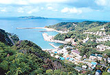
6. Wakihama Nagisa Koen (Wakihama Nagisa Park)
A sand beach that can be seen on the left when entering Oki Port on the Hahajima Maru. There is a space where green turtles can lay their eggs in the turtle tanks adjacent to the park. It is shallow and perfect for swimming. Do not swim into the area off shore beyond the bank, as it is the route for ships.
5 minutes on foot from the port[1]
7. Shokensakiyama (Mt. Shokensaki)
A small mountain on the east side of the village. The view of the small village from here can seem like a miniature garden. It can be easily climbed so it might be good to try when waking up early or to enjoy the evening breeze. However be careful at the top, as it can be rocky.
17 minutes on foot from the port [1]
8. Ishijiro Kaigan (Ishijiro Beach)
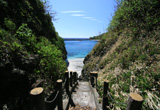
A beach with beautiful white sand, located on the east side within Oki Port, almost like a small private beach. The beach can be accessed by the public trail from the road. Maehama is a swimming distance for those who are confident with swimming.
15 minutes on foot from the port [1]
9. Sunset Theater
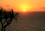
An observation deck at the entrance of the bay of Oki port. Okijima and Hirajima can be seen off shore. A good spot for whale watching from Januray to April, so binoculars are recommended during that season. The Hahajima Maru passes right in front.
5 minutes on foot from the port [1]
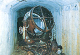
10. Tanshoto Bochiato and Roppon-yubi Jizo (Old Searchlight Base and 6 Finger Jizo)
A sand beach that can be seen on the left when entering Oki Port on the Hahajima Maru. There is a space where green turtles can lay their eggs in the turtle tanks adjacent to the park. It is shallow and perfect for swimming. Do not swim into the area off shore beyond the bank, as it is the route for ships.
25 minutes by car from the port [1]
11. Higashi-Ko Tanshotoka Houdai (Higashi Port Searchlight Batteries)
A small mountain on the east side of the village. The view of the small village from here can seem like a miniature garden. It can be easily climbed so it might be good to try when waking up early or to enjoy the evening breeze. However be careful at the top, as it can be rocky.
20 minutes by car + 7 minutes on foot from the port [1]
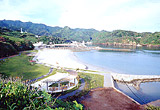
12. Higashi Port
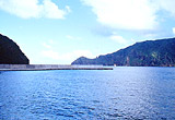
A large port facing the east side of Hahajima. There was a whaling station here until 1985.
20 minutes by car from the port [1]
13. Kitamura elementary school site
The Kitamura elementary school opened in 1887. There was a village in between Okimura and Kitamura in Hahajima before the war. Until the forced evacuation in 1944, Kitamura elementary school was located here. There remains a gatepost that was made by piling up stonerollers of compressors for manufacturing sugar on both sides of the stone steps. The stonewall by the road, covered by Gajumarus (Ficus microcarpa) gives us an image of how it used to be back in the days.
30 minutes by car or 2 hours on foot from the port [1]
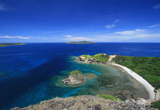
14. Kita Port
A bay on the northern tip of Hahajima. Before the war there was the village of Kitamura here with a population of about 600 people. Regular lines from Tokyo also made stops. There are coral reefs in the water and green turtles can be seen swimming. A good spot for fishing from the rocks.
30 minutes by car or 2 hours on foot from the port [1]
15. Kita-Ko Chukon Hi (Kita Port Monument of Loyalty)
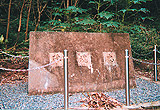
There is an entrance of a public trail at the parking space of Kita Port. This was erected in 1945 by the 309th construction battalion of the navy. The three characters of the monument was placed by engraving on Hahajima’s ross stone.
30 minutes by car + 5 minutes on foot from the sign at the entrance from the port [1]
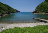
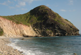
16. Osawa Kaigan (Osawa Beach)
Can be accessed by public trail from Kita Port. Snorkeling in the coral reef is very enjoyable here. Chichijima can be viewed from here on a clear day.
30 minutes by car + 50 minutes on foot from the port [1]
17. Chibusayama
The highest peak on Hahajima with an elevation of 463m. Rich with endemic plants such as Hahajimanobotan (Melastoma tetramerum var. pentapetalum) and Wadannoki (Dendrocacalia crepidifolia). If lucky Meguros (Bonin White-eye), which only exist on Hahajima, can be spotted in the public trail to the top. Chichijima can be seen from here on a clear day.
10 minutes on foot from the port [1] + one circle of the public trail is 4 hours on foot
18. Hyougidaira Undojo (Hyougidaira Sports Ground)
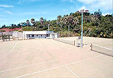
There is a multipurpose ground (1 ground) and tennis courts (2 courts). There are lighting facilities that allow people to play in the evenings when it is cool. Those who wish to use can sign up at the Hahajima branch office (from Monday to Friday).
4 minutes by car from the port [1]
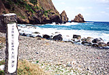
19. Miyukinohama (Miyukino Beach)
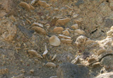
This place was named this way as Emperor Showa collected plant and animal species here during his visit in 1927. A rare fossil of a large foraminifer called nummulite can be seen here. The surrounding area is a special protection zone and marine park.
10 minutes by car + 5 minutes on foot from the port [1]
20. Nankinhama (Nankin Beach)
This place is connected with Miyukinohama (Miyukino Beach) by public trail. A coral reef spreads in the water and whitetip reef sharks can be spotted taking naps under the rocks. The name is said to have come from the fact that Chinese settlers temporarily stayed here in the early period of cultivation of the island.
6 minutes by car + 10 minutes on foot from the port [1]
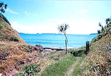
21. Houraine
A small, white beach and a playground by the shore for people who live on the island. The rocks off shore are called Houraine. It is possible to swim across them and can be fun to go around them. The rocks can be difficult to walk on so be careful not to get hurt.
15 minutes by car + 35 minutes on foot from the port [1]
22. Minamizaki
Inside the bay is great for snorkeling with table corals growing under the water. However the current is fast off shore so please be careful. Go down towards the west, right before Minamizaki, and you can find Wai Beach, a beautiful beach with white sands. The name is said to have developed from how people pronounced “white beach” with an accent.
15 minutes by car + 45 minutes on foot from the port [1]
23. Kofuji
The southernmost Fuji in Japan. There is a spectacular view of the coral reef of Minamizaki from the summit.