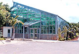
1. B-Ship (Shoko Kanko Hall/ Commerce and Tourism Hall)
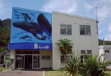
There is a counter of the tourism association as well as the whale watching association, and the village bus office is next door. A tourism facility where you can find all information about sightseeing. This is the starting point for the required times to destinations on this map.
2. Ogasawara Visitor Center
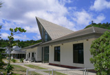
This is the place for visitors to learn about the history and nature of the island. There are models, panels, and slides that introduce all aspects of the island. A real-size canoe that has been restored in the form of when it used to sail is on display.
2 minutes on foot from B-Ship
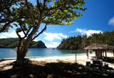
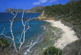
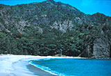
3. Omura Kaigan (Omura Beach)
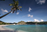
Walk through the grass space of central Omura and Omura Kaigan (Omura Beach) spreads before your eyes. The east side of the beach has a bank for protection and people come to swim or enjoy windsurfing. A good place for having one last swim before getting on the ship.
2 minutes on foot from B-Ship
4. Ogamiyama Koen (Ogamiyama Park)
There is a torii (a Shinto shrine arch) on the mountain behind the Omura shopping district. Here is the Ogamiyama Jinja (Ogamiyama Shrine), and there is a regularly held festival on November 3. The entire area of Ogamiyama is a metropolitan park with public trails going through it, and the Futamiwan (Futami bay) can be viewed from the observation deck. Located not too far from the village, it is also a good spot for enjoying the cool breeze in the evening.
5 minutes on foot from B-Ship
5. Mikazukiyama Tenboudai (Mikazukiyama Observation Deck)
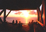
This is an observation deck that stands over the sea on the west side of Chichijima, and the view of the sun setting on the Pacific Ocean from here is spectacular. It is also perfect for whale watching from land from January to April. Hahajima can also be seen from here on a clear day.
7 minutes by car from B-Ship/ 25 minutes on foot
6. Ogasawara Suisan Center (Ogasawara Fisheries Center)
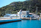
The Ogasawara village covers 1/3 of Japan’s exclusive economic water zone. This is a fishery experimentation facility of Tokyo, and researches for the protection of resources as well as fish culturing are being conducted. It is possible to view the fish and shellfish that live in Ogasawara in the observation building.
3 minutes by car from B-Ship/ 10 minutes on foot
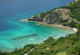
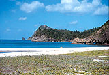
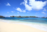
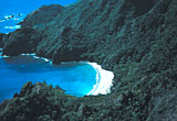
7. Miyanohama (Miyanohama Beach)
A beautiful bow-shaped beach that faces the Anijima-seto (Anijima strait). Perfect for diving or snorkeling as coral reefs have grown in the waters with plenty of tropical fish. However, be careful not to swim out to the strait since the current of the Anijima strait is fast and dangerous.
4 minutes by car from B-Ship/ 20 minutes on foot
8. Tsurihama (Tsurihama Beach)
The word “tsuri” refers to fishing, and this place has been known to be a fishing spot from the old days. The shortest distance of the Anijima strait between the island and Anijima is 500m. The waters are beautiful, but do not go too far away from the beach, as the current is fast. For this reason swimming alone can be dangerous and is not advised.
5 minutes by car from B-Ship + 6 minutes on foot
9. Okumura Undojo (Okumura Sports Ground)
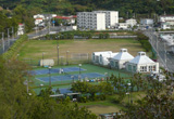
There is a multi-purpose ground (1 ground), tennis court (3 tennis courts), and a gate-ball field (2 fields). People who wish to use can reserve at the clubhouse. There is the Ogasawara Senbotusha no Chinkon no Hi (Monument for the people of Ogasawara who died in the war).
3 minutes by car from B-Ship
10. Ogasawara Kaiyo Center (Ogasawara Marine Center)
This is a facility for the protection and breeding of green turtles. The center is open from the afternoon of the day when Ogasawara Maru arrives until the morning of the day when the Ogasawara Maru leaves. Green turtles can be observed in the tanks displayed, while there are also exhibits of whales and marine organisms.
5 minutes from B-Ship
11. Kanrinmaru Bochi (Kanrinmaru Grave)
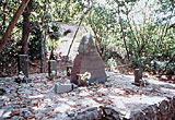
In 1862 the Edo Shogunate dispatched Mizuno Tadanori, a commissioner of foreign affairs, and his party to the Ogasawara Islands to gather information. This is a grave where those who died on the Kanrinmaru were buried, and a “Hyourusha Mefukuhi (monument for those who have drifted)” was also built. This monument was made also for the purpose as proof that the Ogasawara Islands belonged to Japanese territory since long ago, and is designated as a cultural asset of Ogasawara village.
5 minutes by car + 1 minute on foot from B-Ship/ 25 minutes on foot
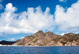
12. Nagasaki Tenbodai (Nagasaki Observation Deck) and the Pillow Lava
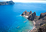
his is an observation deck where the strait of Anijima as well as Anijima can be viewed. The current is also visible that runs like a river. The cape at the bottom right is Nagasaki. The cliff of the pillow lava at the exit of the Nagasaki tunnel is proof that it once used to be a submarine volcano.
9 minutes + 10 minutes on foot from B-Ship
13. Asahiyama
This is the mountain located behind Futami Fishing Port. The inspection team of the Shogunate that arrived on the Kanrinmaru raised the Japanese flag on the top of this mountain. There is a public trail that leads to the summit, and the color of Futamiwan (Futami Bay) seen from here is stunning.
11 minutes + 10 minutes on foot from B-Ship
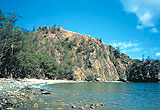
14. Sakaiura (Sakaiura Beach) and Hinkoumaru
A beach with quiet waves, located in the eastern section of Futamiwan (Futami Bay). Off the shore is the rusted Hinkoumaru that was hit by a torpedo during the Pacific War (1944).
6 minutes + 4 minutes on foot from B-Ship/ 4 minutes on foot from Sakaiura Kaigan bus stop
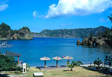
15. Ogiura (Ogiura Beach)
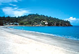
A beach located on the other side of Futami Port with the view of the Omura district right in front. There is a rest house with parking spaces, toilets, and showers. A good place for families to come together for swimming in the sea.
10 minutes by car from B-Ship/ Right in front of Ogiura Kaigan bus stop
16. Ogasawara Jinja (Ogasawara Shrine)
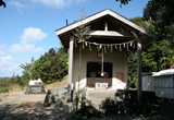
This is a shrine that worships Ogasawara Sadayori, who is said to be the founder of the Ogasawara Islands. The shrine was built after the reversion. A festival is held every year on July 26. A government office was place in Ogiura in the beginning of the cultivation period by the Meiji government. Within the precinct there are several monuments such as the “Ogasawara Kaitaku no Hi (Ogasawara Cultivation Monument)”, the “Ogasawara Niihari no Hi (Ogasawara Development Monument)”, and the “Nihohe Hi (Nihohe Monument). These are important materials for learning the history of the development of Ogasawara, and are designated as cultural assets of Tokyo and the village.
10 minutes by car + 3 minutes on foot from B-Ship/ 3 minutes on foot from Ogiura Kaigan bus stop
17. Ogasawara Anettai Nogyo Center (Ogasawara Subtropical Agricultural Center)
An agricultural research center where experiments are conducted by making use of the subtropical climate. There are colorful hibiscuses and bougainvilleas growing inside the garden. Visitors can freely come to view the garden on display with a collection of endemic plants of Ogasawara as well as tropical plants from around the world.
12 minutes by car from B-Ship/ 2 minutes on foot from Nogyo Center bus stop
18. Kopepe Kaigan (Kopepe Beach)
The name comes from a native of the island, originally from the Gilbert Islands, who used to use this beach. The beach is rich with corals and good for snorkeling.
14 minutes by car + 4 minutes on foot from B-Ship
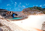
19. Kominato Kaigan (Kominato Beach)
One of the most beautiful beaches in the Ogasawara Islands. Walk through the windbreak forest of Tamanas trees (brassica oleracea) and Hamagiris (hernandiaceae ) and a pure, white beach appears in front you. The bay is shallow with quiet waves, and is possible to swim with bare feet.
16 minutes by car + 2 minutes on foot from B-Ship/ 2 minutes on foot from Kominato Kaigan bus stop
20. Nakayama Toge (Nakayama Pass)
Cross the Yatsusegawa (Yatsuse River) from Kominato, follow the public trail from there and you will arrive at Nakayama Toge (Nakayama Pass). On the north side you will find Kominato Kaigan (Kominato Beach) and Kopepe Kaigan (Kopepe Beach) below. Further away is the Futami Wan (Futami Bay). The south side shows the valleys of Minami Fukurozawa, Buta Kaigan (Buta Beach), and the islands around Minamijima.
16 minutes by car + 18 minutes on foot from B-Ship/ 3 minutes on foot from Kominato Kaigan bus stop
21. Buta Kaigan (Buta Beach)
A bow shaped beach that can be reached by walking down from Nakayama Toge (Nakayama Pass). There are coral reefs and plenty of tropical fish as well as marine life. There are whitetip reef sharks and stingrays as well. They won’t attack, but do not touch them.
16 minutes by car + 30 minutes on foot from B-Ship/ 30 minutes on foot from Kominato Kaigan bus stop
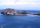
22. John Beach
The area of Minamizaki is the only limestone area on Chichijima, and so the sand on the beach is bright and pure white. There are beach rocks that develop by the hardening of sand on the seashore. Sceneries can change as large and small reefs appear in the Minamijima Seto (Minamijima strait).
16 minutes by car + 80 minutes on foot from B-Ship/ 80 minutes on foot from Kominato Kaigan bus stop
23. Jinny Beach
The southwestern most beach of Chichijima. It is located just south of John Beach, but there is no trail. The beach can only be landed from sea by using a kayak.
16 minutes by car + 100 minutes on foot from B-Ship/ 100 minutes on foot from Kominato Kaigan bus stop
24. Green Pepe
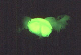
A fungus that wondrously glows in the dark. It’s size is about 1cm, and the Japanese name is “Yakoutake”. They develop the most from May to November, and can be most spotted on humid nights a few days after it has rained. This is a place where it can be easily seen along the road.
16 minutes by car (via Oogiura) from B-Ship
25. Chuozan (Mt. Chuo)
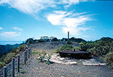
This is the peak of central Chichijima with an elevation of 318m and a 360-degree view. There is Futami Wan (Futami Bay) on the west. On a clear day Mukojima can be seen about 70km north as well as Hahajima about 50km towards the south. A remain of the base of a radar facility is at the summit.
19 minutes by car (via Ogiura) + 5 minutes on foot from B-Ship
26. Hatsuneura (Hatsuneura Beach)
A beach surrounded by steep mountains. A trail has been made from the road, however the slope is very steep. The sand on the beach is “Uguisuzuna (oriole-green sand of boninite)”. There are many endemic plants around the trail.
19 minutes by car (via Yoakezan) + 30 minutes on foot from B-Ship/ 40 minutes on foot on the way back as the slope is steep
27. Hatsuneura Tenboudai (Hatsuneura Observation Deck)
An observation deck from where Higashijima and Hatsuneura can be seen. The headless Ninomiya Sontoku Zo (Statue of Ninomiya Sontoku)” on the other side of the entrance of the observation deck was brought by the Japanese army from Omura elementary school.
15 minutes by car from B-Ship
28. Minamijima
An island made from limestone with a submerged Karst topography. Swimming in Ogiike is an out-of-this-world experience. Routes are specified in order to preserve the precious natural environment, and people must be accompanied by a guide. (There are periods when people are not allowed to enter.)